Malaysian Airlines flight MH370: What really happened?
The inescapable conclusion is that flight 370 simply vanished in some way that we do not yet understand. (Belzer, Noory & Wayne 2015)
_9M-MRO_-_color.jpg) |
| The original MH370 Boeing 777-200ER. Source: Wikipedia. |
Abstract: At 1.20am on 8 March 2014, forty minutes into the flight of Malaysian Airlines MH370 from Kuala Lumpur to Beijing, lithium-ion battery fires and explosions in the forward cargo bay resulted in the loss, or shutting down, of many of the aircraft's electrical systems, including communications and secondary radar transponders. The pilots immediately decided to turn back towards Penang, Malaysia. The following possible scenario then unfolds, involving the deaths of passengers and crew from toxic fumes, extreme heat, acrid, asphyxiating smoke and high altitude decompression: (1) the pilot/s fly the plane part of the way southwest towards Penang, passing out en route; and (2) the plane is taken over by remote control by US Forces and, after passing Penang, then flown northwest and west to the Maldives and Diego Garcia in the Indian Ocean, where it is ditched near the Maldives (the Sergio Cavaiuolo scenario) or top secret American military base on Diego Garcia (the Ashton Forbes scenario). The subsequent dispersal of items of debris (real or diversionary) westerly and south-westerly of Diego Garcia supports this scenario. The external intervention is by American military forces, whereby MH370 flies away from heavily populated areas such as Thailand, Malaysia, and the island of Sumatra in Indonesia. This operation is supported by military radar and top secret satellite surveillance and drone backup. Back-engineered off-world technology in the form of anti-gravity and warp drive-inducing orbs are also utilised in secreting the Boeing 777-200ER aircraft towards the Maldives and Diego Garcia. The "above Top Secret" nature of the technologies employed by the Americans gives rise to the classified status of the operation and subsequent mishandling by Malaysian authorities in the aftermath of the disappearance. An official scenario is developed and adhered to, based on misinterpreted Inmarsat satellite data. It states that the plane crashed into the sea off the west coast of Australia. This erroneous narrative persists, despite the existence of a corrected, alternative interpretation by an Australian engineer in 2015 which points to the Maldives / Diego Garcia scenario. The present article represents the views of the author, utilising all available data. It varies in large part from the official narrative as outlined in the 2017 and 2018 reports by Australian and Malaysian authorities, and numerous YouTube videos such as the History Calling documentary of March 2024.
 |
| MH370 orb interception images (l. drone; r. satellite), c. 2.40 am [18.40 UTC], 8 March 2014 + video (below). |
 |
| Map of possible MH370 search area based on Inmarsat satellite I3F1 data, with Diego Garcia marked by a yellow cross X. Below is a map of the route of the plane, based on that data, and which supports the Maldives / Diego Garcia scenario (Cavaiuolo 2022). |

--------------------
Contents
- Preamble
- What really happened?
- Summary of evidence
- Salvatore Pais and the Orbs
- Elizondo video
- Discussion
- Videos
- Letter to Ashton Forbes
- References
--------------------
There are some things that I can tell you, and some things that I can't. (Malaysian civil aviation chief, Azharuddin Abdul Rahman, 11 March 2014)
[Modern commercial passenger] planes don't just disappear (Florence de Changy 2016)
1. Preamble
On 8 March 2014 Malaysian Airlines flight MH370 with 227 passengers and 12 crew (total = 239) on board disappeared on a flight from Kuala Lumpur to Beijing. According to the Diego Garcia Whistle-blower's Letter to Ashton Forbes (10 January 2024), 200 of those on board died, and the rest survived, including some Chinese and Malaysians. Over the following months and years various investigations into its fate were carried out, though the aircraft was never found, no bodies located, or black box recorders recovered. This was unprecedented. Items of a Boeing 777-200ER subsequently washed up on beaches in east Africa and east of Madagascar. Some have subsequently been linked to the missing aircraft. As a result of all this, the fate of the flight remains shrouded in mystery. Since 2014 a number of official accounts of what may have happened appeared, alongside regular media updates and documentaries both supporting and querying the official narrative and ongoing concerns of family members. One of the earliest, and most plausible, concerned the catastrophic impact of a fire onboard (Goodfellow 2014). As time passed, reports appeared on social media platforms such as YouTube, Facebook, TikTok, Twitter X and Reddit with theories of what possibly, or likely, took place. Many of these do not agree with the official line and have largely been ignored. So-called conspiratorial narratives abound, alongside an increasing number of post-2022 AI-generated presentations on social media which rehash previously known information. The multi-part podcast and YouTube video series by Jeff Wise and Andy Tarnoff addresses many of these theories, though ultimately goes down the wrong path (Wise & Tarnoff 2023-2024). One left-of-field theory, and the one perhaps most easily ridiculed, involved man-made UFOs - unidentified flying objects - and a veritable black hole. Yet, there was an element of truth in that scenario. Coupled with accusations of coverups and the utilisation of top secret tracking technologies, a deeper dive was therefore called for into the question of What really happened to flight MH370?
As the tenth anniversary on 8 March 2024 of the disappearance of MH370 came and went, a plethora of media reports appeared, though none took on board the information which forms the basis of the present article - information which, in the opinion of this writer, is the only reasonable, rational and fact-based explanation (actually a group of explanations), so far offered, and the one which owes much to a host of previous researchers.
At the time of the plane's disappearance back in March 2014, the present author read with interest reports in the media of events surrounding the flight and its possible fate. Within a month or so he supported a view - shared by others - that the plane had been taken to Diego Garcia, the secret American military base located in the middle of the Indian Ocean. In a waking dream, the author felt that upon the plane's arrival at the island the passengers were still strapped in their seats, and assumed this meant they landed safely. There was no evidence publically given at the time to support such a scenario, and it was simply a gut feeling, though there were rumours of a Diego Garcia final destination. Subsequent events a decade later - on 13 March 2024 to be precise - would point to the possibility that this may have been more than just a suspicion, or transitory remote viewing, and that the passengers and crew suffered a fate darker than the author originally suspected back in 2014.
This 2024 revelation was primarily due to the research of the American Ashton Forbes, which forms the basis of the discussion below. This is supplemented by the findings between 2015-2022 of Australian aerospace systems engineer Sergio Cavaiuolo who redressed errors in the initial interpretation of the Inmarsat data, with the L3F1 satellite located 35,800 km above sea level over the Indian Ocean. The findings of Forbes and Cavaiuolo highlighted the significance of the on-board lithium-ion battery fires and explosions, and the fact that MH370 did not go south after it disappeared near the Nicobar Islands west of Malaysia, and as the Inmarsat data had initially been interpreted to suggest. In fact, it is proposed that it flew west towards the Maldives, and then south towards Diego Garcia - a fact which is likewise, strange to say, supported in large part by the Inmarsat data. Cavaiuolo has proven that the data, as officially relied upon by the authorities, was wrong (Cavaiuolo 2022). His findings coincide with the multiple sightings of the plane at the Maldives early in the morning of 8 March 2014, whilst still able to fly under its own power.
The other aspect of the tragedy that was fleshed out by Forbes was the UFO / Alien technology elements referred to above. Like Forbes, the present author was a relative newcomer to the field of ufology and extraterrestrials, taking up the topic in earnest for the first time only during October 2024. However, some recent research into the United States' enigmatic TR-3B triangular spacecraft with anti-gravity and warp drive capabilities also tweaked an interest in the fate of MH370 when a somewhat mysterious reference was made to the involvement of UFOs in its disappearance. In this instance, the UFOs (three orbs) were of terrestrial construction, but ultimately of extraterrestrial origin.
Presented below, therefore, is a chronological summary of what the present author believes to be the ultimate fate of MH370. It is supplemented by links to videos and articles which discuss that scenario and others, including those of the numerous debunkers and individuals who adhere to the official narrative put forward by both the Malaysian government and its Allies, led by the United States and Australia. Links to representative remote viewing and psychic investigations into the mystery of the disappearance of MH370 are also included, alongside the largely fact-based scientific analysis.
Somewhat mysteriously, significant elements of the available evidence which are ignored, neglected, or debunked by the official narrative. They include the following:
- Catastrophic fire on board due to lithium-ion battery fires and explosions, with the fire continuing for at least 2 hours. [There is ample evidence for this, and for its catastrophic nature.]
- Switching off of electrical busses by the pilots as normal procedure in the event of a fire. [This substantially explains the substantial loss of communication with the plane and the crew. The fire may also have damaged or destroyed the busses.]
- Possible hull decompression due to fire and explosions, resulting in immediate loss of life. [This could have occurred in addition to loss of life from the fire and toxic fumes.]
- Witness evidence, as in reports of a "plane on fire" in both the South China Sea and Strait of Malacca near Aceh and Nicobar.
- Witness evidence, as in the passage of the plane over the Maldives at 9.15am Malaysian time (6.16 am local time), as witnessed by at least 20 individuals.
- Incorrect interpretation of the Inmarsat data, placing the plane on a trajectory due south towards Antarctica rather than due west towards the Maldives and southwest towards Diego Garcia. [This misinterpretation of vague evidence appears to be part of a diversion plan.]
- Live video from an American spy satellite. [Confirms intervention by US military forces.]
- Live video from an American drone. [Confirms intervention by US military forces.]
- Location of the debris close to the point of final impact of the plane in the western Indian Ocean. [Debunks the southern ocean crash scenario.]
- Hydroponic evidence that the plane came to ground near the Maldives / Diego Garcia at 9.34am Malaysian time. [Debunks the southern ocean crash scenario.]
- Remote control intervention of the plane by Boeing and the US military. [Explains the route taken by the burning plane.]
- Detailed radar and satellite evidence of the location and fate of the plane held by the United States and other governments, military authorities and commercial entities. [Failure to release this information confirms the coverup nature of the operation.]
All of the above are mentioned and referenced in the text below. It is therefore obvious that the authorities have maintained a coverup, and held to the line that all the evidence utilized must adhere to the initial March 2014 Inmarsat data interpretation, rather than taking on board available evidence and questioning the integrity and veracity of that initial interpretation, especially in light of a subsequent reinterpretation. This author of this article has summarized the evidence provided below within the following YouTube video presentation.
Michael Organ, Malaysian Airlines MH370: What happened?, YouTube, 11 April 2024, duration: 57.35 minutes.
----------------------
2. What really happened?
The following is a chronological summary of what the present author believes to be the fate of flight MH370, based in large part on the research of Ashton Forbes as carried out between August 2023 and March 2024 and publically presented on various social media channels, and that of Sergio Cavaiuolo between 2015-2022. Reference to their comprehensive research is recommended, with numerous links below.
The chronology can be broken down into seven sections: (1) Cargo and boarding; (2) Departure; (3) Fire on board; (4) Penang; (5) Radar disappearance; (6) Orb interception; (7) Maldives & Diego Garcia, and (8) Ditching. Excerpts from the cockpit transcript are included below along with first-hand accounts from various media reports and the numerous eye witnesses at various stages in the flight. Also note that some of the times allocated below are approximate due to lack of precise information and conflicts in the public record.
NB: In the following, both local Malaysian time and Coordinated Universal Time are provided, with the latter indicated in brackets, e.g. 11.54pm. [15.54UTC].
Cargo and Boarding
Friday, 7 March 2014
* 9am. [1.00UTC] A cargo of Motorola lithium-ion batteries weighing 221 kg is loaded at a Penang factory and transported to Kuala Lumpur International Airport for dispatch to Shanghai, China, on board flight MH370. Prior to placement in the forward cargo hold, near the electronics array, no check is made of the batteries, which can be subject to spontaneous combustion and therefore have a catastrophic impact upon a flight. Once one battery ignites and explodes, it can also cause all the other batteries nearby to do the same over an extended period, giving off extreme heat, toxic fumes and dark black smoke. It is extremely difficult to extinguish such fires, and dangerous to approach as the batteries can explode randomly. Any resultant breach of the hull at cruising altitude of 35,000 feet could result in the death of passengers on board within a few minutes, due to depressurization and loss of oxygen, aside from the toxic effects of the batteries and smoke which could induce asphyxiation and hypoxia. The dangerous goods notification report to the captain (the NOTOC) did not specifically refer to the the batteries in the cargo bay as dangerous goods, though it should have.

 |
| Location of Motorola lithium-ion battery pallets (purple E). Source: 2018 Report. |
This aspect of the flight cargo and its inherent danger is noted during May 2014 (two months after the loss of the plane), and Captain Ross Aimer confirmed this scenario during 2018 (Irving 1 May 2014; Mystery of lithium-ion batteries MH370 disappearance, Press Trust of India, 3 May 2014; Engel 16 October 2015; Taylor 30 July 2018; Richard 12 November 2018; Birchall 24 November 2018; Rivers 24 November 2018). Unfortunately it is largely dismissed in the official investigations.
- 11.20pm (Malaysian Time). [15.20UTC] Passengers begin boarding MH370.
- 11.54pm. [15.54UTC] The ACARS (Aircraft Communication Addressing and Reporting System) starts, indicating the airplane is powering up and the pilots are on board. ACARS utilises two satellites to provide regular reports on the operation of the plane and its location. This supplements the internal black box recorders and two other transponders which report location data to ground control centres. All told, twenty antennas are located on the plane for interactions related to communications, location, and weather radar. The ACARS computer is located adjacent to the forward cargo hold, and beneath the cockpit / First Class passenger section of the plane. This area is also close to the cargo bay where the lithium ion batteries were loaded.

Departure
Saturday, 8 March 2014
- 0.25am. [16.25UTC] MH370 taxis towards runway 32 Right for final departure from Kuala Lumpur International Airport.
- 0.40.38am. [16.40UTC] Pilot: 32 Right. Cleared for takeoff. MAS370. Thank you. Bye. Source: MH370 Cockpit recording, 8 March 2014, CNN, YouTube, duration: 3.16 minutes.

- 0.41am. [16.41UTC] The aircraft powers up for take off.
- 0.42.00am. [16.42UTC] Flight MH370 takes off, heading north northeast (NNE) towards Beijing where it is due to arrive at 6.30am. It initially climbs to 18,000 feet.
- 0.46am. [16.46UTC] Climbs to 25,000 feet.
- 0.50am. [16.50UTC] Climbs to a cruising altitude of 35,000 feet.
- 1.01am. [17.01UTC] Captain reports plane at 35,000 feet.
- 1.07.29am. [17.07UTC] First and final inflight ACARS transmission from the plane. The system normally provides regular updates on the status of the aircraft every 30 minutes. However the next report - due at 1.37am [17.37UTC] - never takes place, indicating that the system had shut down in the interim.
- 1.07.55am. Captain: Malaysian Three Seven Zero .... maintaining level three five zero.
- 1.19.29am. [17.19UTC] Malaysia air traffic control: Malaysian Three Seven Zero, contact Ho Chi Minh, 120.9. Goodnight.
[Comment: This is the normal control tower notification to the pilots of moving over from Malaysia ground control to Vietnamese ground control.]
- Captain: Goodnight, Malaysian Three Seven Zero.
[Comment: There are no further cockpit communications from MH370 following this response from the captain. It is noted that the captain did not repeat the reference to the Ho Chi Minh 120.9 radio channel in his reply, as was the norm. The Pilot Mentour (2024) suggests that the pilot sounds busy at that point. Perhaps there are indications of something wrong, but nothing to report at that specific moment.]
[During this period the plane is being monitored by, or is visible to, a number of different ground radar and aerial satellite monitoring systems, including GPS. These are indicated in the tables below. Not all of the available data from these sites is made public in the subsequent investigation into the disappearance of MH370.]
 |
| MH370 Detection Timeline. Source: Lomas 2024. |
Fire on board
Shortly after the Captain says Goodnight, Malaysian Three Seven Zero, there is a problem on board and the situation deteriorates quickly.
Malaysian Airlines - Lithium Ion Battery Fire, Ashton Forbes, YouTube, 30 July 2024, duration: minutes.
- circa 1.20am. [17.20UTC] It is assumed that fire alarms go off in the cockpit as lithium-ion batteries catch fire and smoke fills the air, streaming from the forward cargo bay into the cockpit area. There is also likely associated explosions in the forward cargo section, next to the electronics array. The pilots are forced to react according to standard procedure, which includes turning off electrical systems in the event of a fire on board and, as a result, making the plane go silent. The fire and explosions can also directly result in loss of some of the aircraft's communications systems, due to the extreme heat and thick smoke associated with the lithium-ion battery fires and their close proximity to the under-cockpit electronics and communications array. As a result, the pilots are apparently no longer able to report their situation to Malaysian or Vietnamese control, as it is assumed would have been one of their first actions, especially on the part of the most experienced pilot. Localised plane-to-plane radio is apparently still available in part, though outward calls may be disabled.
 |
| The MH370 aircraft, with location of the forward cargo bay in yellow, close to the cockpit. |
- Chris Goodfellow, 18 March 2014 (Article): The following presents a likely scenario for the fate of MH370 due to the emergency created by the fires on board and the initial action of the pilots.
A startlingly simple theory about the missing Malaysia Airlines jet.
There has been a lot of speculation about Malaysia Airlines Flight 370. Terrorism, hijacking, meteors. I cannot believe the analysis on CNN; it’s almost disturbing. I tend to look for a simpler explanation, and I find it with the 13,000-foot runway at Pulau Langkawi. We know the story of MH370: A loaded Boeing 777 departs at midnight from Kuala Lampur, headed to Beijing. A hot night. A heavy aircraft. About an hour out, across the gulf toward Vietnam, the plane goes dark, meaning the transponder and secondary radar tracking go off. Two days later we hear reports that Malaysian military radar (which is a primary radar, meaning the plane is tracked by reflection rather than by transponder interrogation response) has tracked the plane on a south-westerly course back across the Malay Peninsula into the Strait of Malacca. The left turn is the key here. [Chief pilot] Zaharie Ahmad Shah was a very experienced senior captain with 18,000 hours of flight time. We old pilots were drilled to know what is the closest airport of safe harbor while in cruise. Airports behind us, airports abeam us, and airports ahead of us. They’re always in our head. Always. If something happens, you don’t want to be thinking about what are you going to do – you already know what you are going to do. When I saw that left turn with a direct heading, I instinctively knew he was heading for an airport. He was taking a direct route to Palau Langkawi, a 13,000-foot airstrip with an approach over water and no obstacles. The captain did not turn back to Kuala Lampur because he knew he had 8,000-foot ridges to cross. He knew the terrain was friendlier toward Langkawi, which also was closer. Take a look at this airport on Google Earth. The pilot did all the right things. He was confronted by some major event onboard that made him make an immediate turn to the closest, safest airport. When I heard this I immediately brought up Google Earth and searched for airports in proximity to the track toward the southwest. For me, the loss of transponders and communications makes perfect sense in a fire. And there most likely was an electrical fire. In the case of a fire, the first response is to pull the main busses and restore circuits one by one until you have isolated the bad one. If they pulled the busses, the plane would go silent. It probably was a serious event and the flight crew was occupied with controlling the plane and trying to fight the fire. Aviate, navigate, and lastly, communicate is the mantra in such situations. There are two types of fires. An electrical fire might not be as fast and furious, and there may or may not be incapacitating smoke. However there is the possibility, given the timeline, that there was an overheat on one of the front landing gear tires, it blew on takeoff and started slowly burning. Yes, this happens with underinflated tires. Remember: Heavy plane, hot night, sea level, long-run takeoff. There was a well known accident in Nigeria of a DC8 that had a landing gear fire on takeoff. Once going, a tire fire would produce horrific, incapacitating smoke. Yes, pilots have access to oxygen masks, but this is a no-no with fire. Most have access to a smoke hood with a filter, but this will last only a few minutes depending on the smoke level. (I used to carry one in my flight bag, and I still carry one in my briefcase when I fly.) What I think happened is the flight crew was overcome by smoke and the plane continued on the heading, probably on George (autopilot), until it ran out of fuel or the fire destroyed the control surfaces and it crashed. You will find it along that route – looking elsewhere is pointless...
- It is possible the fire and explosions result in a minor hull breach, which can have a devastating impact at a high cruising altitude of 35,000 feet. It can give rise to hypoxia which could have resulted in the death of the passengers and most of the crew within a few minutes.
- Raf Sanchez, 20 March 2014 (Article): This article also offers a likely scenario based on the impact of the fires on board.
Missing Malaysia Airlines flight MH370 - were crew trying to save smoke-filled plane?
Washington: Billie Vincent, the former head of security at America’s Federal Aviation Authority (FAA) and a key witness in the Lockerbie bombing trial, said on Wednesday (19 March 2014) he believed that Flight MH370 went off course in a desperate attempt to reach safety as the cabin filled with smoke. "As opposed to being hijackers, the crew were heroically trying to save the airplane, themselves and the passengers when this catastrophe hit," he told The Daily Telegraph. Mr Vincent said he believed MH370 had suffered a ‘‘catastrophic event’’ that filled the cabin with smoke or noxious fumes shortly after the pilots made final contact with ground control at 1.19am on March 8. He said smoke could have been caused by an electrical fire, hazardous materials in the cargo hold or a small bomb that failed to destroy the aircraft. The fire could have knocked out the aircraft’s transponder and the Aircraft Communications Addressing and Reporting System (ACARS), he said. The disabling of the two systems has been used as evidence of foul play, but Mr Vincent said shutting down the ACARS deliberately would involve a complicated process, beyond the training of most pilots. The fire would also have caused both the cabin and cockpit to fill with smoke. As they realised what was happening, the crew turned the aircraft west towards Langkawi, a cluster of Malaysian islands, he said. That would explain why the flight left its original path towards Beijing. The smoke and confusion in such ‘‘horrendous conditions’’ would also explain why the aircraft climbed to 13,716 metres (45,000 feet) and then fell erratically back to 701 metres (23,000 feet), he said.
[Comment: Goodfellow, Vincent and others almost immediately after MH370 disappeared pointed out the catastrophic nature of fire on board modern aircraft, with numerous examples to support their statements (Cawthorne 2017). Fire can quickly affect electrical and hydraulic systems, weaken structural integrity and inhibit control of the plane by those on board as a result of fire, heat, smoke, toxic fumes and subsequent depressurization. Fires can come on very quickly, with systems notifying pilots and crew too late, giving rise to impacts which are not able to be addressed. Some aircraft procedure manuals tell pilots to shut down electrical systems immediately and then gradually bring them back online - as the MH370 pilots may have attempted to do - whilst others do not. Examples exist where fire cut systems without warning. Whatever scenario is raised, the fact remains that the fire on board scenario is usually both catastrophic and tragic. The ACARS computer, for example, is located in the lower part of the aircraft, adjacent to the forward cargo bay, and not easily accessible to the crew during the flight. This further suggests that the lithium-ion battery fires had impacted upon that section of the plane and was the ultimate cause of the disaster. In subsequent official discussions around the fate of flight MH370, fire is invariably set aside because of the subsequent behaviour of the plane and its obvious controlled flight for another six hours. A plausible reason for that is outlined below and therefore, in the mind of the present writer, the fire on board scenario is considered the best and most obvious one to explain what happened and the later actions. It does not, of its own, explain the plane's disappearance, even though it was the direct cause of that. Most such fires would have resulted in a crash landing, with millions of pieces of debris scattering on the ground or upon the surface of the ocean. This did not happen. What did happen after 1.19am [17.19UTC] is set out below.]
- 1.20.31am. [17.20UTC] MH370 passes the IGARI waypoint but does not report in to Vietnam control as requested one minute earlier. The pilots are obviously unable to do this, due to there being an emergency on board and their systems going down.
- 1.21.13am. [17.21UTC] The MH370 secondary radar transponder stops operating, indicated by the sudden disappearance of the Mode S symbol for MH370 from civilian control tower secondary radar screens. The loss of Mode S approximately 1 minute after the loss of verbal communication may have been due to the fire on board, or the electrical
busses being shut down by the pilots, or both. The plane is thereafter invisible, or unidentifiable, to civilian ground control by this satellite-based method. If in range it will remain on primary radar screens for a period, but without any specific identification for the radar operators.
[Comment: Secondary radar is associated with four transponders in the plane communicating with satellites and other land-based ground stations. Primary radar is the traditional land-based system which is maintained by military and civilian authorities. Primary radar has limited coverage, usually extending in a circle with a radius of circa 200 nautical miles, whilst secondary radar theoretically has unlimited global coverage, dependent on the position of the relevant satellites.]
[Comment: This loss of verbal and electronic communication with the plane is likely due to the catastrophic damage to the electronic systems from the lithium-ion battery fire / explosions, the likely action by the pilots in pulling the main busses in an attempt to stop or isolate an electrical fire, and the impact of the fire on the passengers and crew. The direct fire impact may be ad hoc and result in systems such as flight control being unaffected, whilst others such as landing gear operation may also have suffered during the extended period of the flight in which the fires raged, and the problematic proximity of the loading bay to the landing gear. Later ground level observance of the fire on the plane points to its significant impact. Reference: Malaysian Airlines Flight 370 satellite communications (Wikipedia).]
[Comment: Numerous commentators accuse the pilot/s of turning off the ACARS transponder and therefore implying their role in a conspiracy involving the meaningful disappearance of MH370. This is a wrong assumption and must be disregarded, as Goodfellow noted it can be part of standard operating procedure during an onboard fire. This action is also used to reinforce the claim that somebody was in control of the plane until it reached its final destination after running out of fuel, or reaching a desired termination point, around 9.34am. It may seem the only logical conclusion, however, it is rejected within the current article in regard to allocating blame to the chief pilot, and an alternative explanation is presented, namely, that an onboard disaster affected the operation of the transponders. Whilst the pilots were likely alive at the time of the loss of the ACARS transponder, this does not therefore imply their presence throughout the totality of the remainder of the flight.]
- At all times during the first 2-3 hours of the flight, the plane is visible to traditional, ground-based, military and civilian radar, including those belonging to the Malaysian (reported), Thailand (not reported) and Indonesian (not reported) military. In addition, and more significantly, United States secret surveillance technologies, including ground-based and aerial radar and spy satellites, are also available, 24/7. The Malaysian military radar information was not disclosed until four days after the flight disappeared. One reason given for this was that: ... they did not want to disclose the capability of the military asset (CNA Insider 2024). This suggests a number of things: (1) that the information available to the Malaysian and US authorities was at a level of detail that they did not wish to reveal to their so-called enemies; (2) that the information they had would compromise their activities, such that perhaps there role in the disappearance would cast a negative light on their activities. Whatever the truth, the fact of the statement points to a coverup and withholding of vital information, regardless of family and airline concerns.
- 1.23.13am to 2.22.12am. [17.23UTC to 18.22UTC] Malaysian civilian ground (primary) radar data from Kata Baru Airport, plus unidentified military radar (Blips), is available to track MH370 during this period. The following table and chart reveal variations in height and speed.
 |
| Military and civilian primary radar data available for the period 1.23.13am to 2.22.12am. |
 |
| Height and speed data from military and civilian primary radar. Source: Report 2018:8. |
- The History Calling documentary notes the following in regards to the plane's behaviour at this time: Although [Malaysian] military radar did provide airspeed and altitude readings, according to both written reports (2017 and 2018) ... these readings are inherently unreliable and showed the plane doing things beyond its capability.... There have been speculation that the plane ascended to about 40,000 feet and that it was deliberately depressurized to render the passengers and crew unconscious and very quickly dead of hypoxia.
[Comment: It can be seen from the above information that immediately after the fire commences, and over the following 16 minutes, the pilots (1) increase airspeed (from 451 to 592 knots / 835 to 1096 kph) possibly in an attempt to extinguish the fire and also reach safety over land as soon as possible, and (2) take the plane from cruising altitude of 35,000 feet to 47,500 feet in an attempt to deprive the fire of oxygen and help the onboard extinguishers dowse the flames. This is one of the worst scenarios the pilots of a passenger aircraft can ever face - choking smoke and fumes, lack of certain systems functionality, and loss of outside communications. The present author does not reject this data, unlike the official investigators.]
- 1.22am. [17.22UTC] The plane and all the associated ACARS and other data that has been publically released up to this point in time has now apparently disappeared from related satellite discovery which feeds into ground control centres and back to Boeing. This suggests partial electrical failures on board the aircraft and pilot initiated action as part of procedure.
[Comment: Access to United States military radar and satellite flight records was never publically provided to civilian authorities in order to add precision to the available limited data regarding the plane's situation. In fact, a media report four days after the disappearance (12 March 2014) states:
Spy satellites find no evidence of explosion. Also raising doubts about the possibility of an attack is that the United States extensively reviewed imagery taken by spy satellites for evidence of a mid-air explosion, but saw none, a US government source said. The source described US satellite coverage of the region as thorough.
[Comment: This is a significant, but very limited report, as it only addresses the issue of visual evidence of an explosion. It is also points out that satellite coverage of the region is thorough, but then does not officially provide access to any of that coverage. The data available to the US should have been made public at the time. It is obvious from reading contemporary media reports that unattributable information was flowing between the US authorities - military and civilian - and the Malaysians. Much was deemed secret by the Americans, and much remained hidden. As such, the public and media quickly became critical and suspicious of how the search was being handled and of what they were being told regarding the disappearance of flight MH370. If the Americans were stating that there was no evidence of an explosion, this leaves open the possibility of a controlled ditching at the end of the flight. It is also obvious that there was no explosion as the early part of the flight, as it carried on out into the Indian Ocean.]
[Comment: There are no cell phone calls made from MH370, indicative of (1) out of range of towers; (2) no Wi-Fi available to the passengers; and (3) likely catastrophic depressurization which, in combination with smoke and toxic fumes, resulted in death, especially as passenger oxygen masks (assuming they were automatically deployed) became redundant after about 22 minutes. Cockpit masks could last up to 27 hours.]
- In 2019 Indonesian fisherman Rusli Khusmin claimed to have seen MH370 crash near the MEKAR waypoint. He noted: I saw the plane moving from left to right like a broken kite. There was no noise, just black smoke as a result of fires before it crashed into the water. There was a strong smell of acidic fumes in the air before the plane went down.
[Comment: Elements of this account ring true, though others do not. Firstly, the plane did not crash at this point, though if the fisherman saw the plane disappear over the horizon, this may explain his belief that it crashed.. Reference to "no sound" and erratic flight path suggests that the engines were not operating at that point and the plane was in a glide, or some sort of automatic controlled flight. The references to black smoke and strong smell of acidic fumes supports the lithium-ion battery fire scenario.]
- 1.23am. [17.23UTC] Due to the catastrophic situation on board, the captain and co-pilot make the logical decision to turn around and head to the nearest airport to land. The plane therefore makes a 40 degree turn to the right, followed by a 180 degree turn to the left and heads back to Penang. The pilot is familiar with the airport there. It is possible that initially the co-pilot at the controls started a right turn to head back to Kuala Lumpur, but then the captain took over and decided to head towards Penang and therefore made a sharp left turn towards that more northerly, and more familiar, location.
- 1.23.38am [17.23.38UTC] MH370 makes a left turn. This is just three minutes after the initial impact of the fires.
- 1.24.57am [17.24.57UTC] Blip #1: Military radar. Travelled at up to 39,116 feet and at an increased speed of 592 knots.
- From this point it has been noted that the plane flies erratically along the path to Penang. This is understandable, considering the situation on board. It may also mean that auto-pilot was not engaged, or operating, and that the pilots were having difficulty controlling the plane, especially if their cockpit was engulfed in smoke and heat and they were wearing oxygen masks. The pilots may also have been suffering the effects of the toxic fumes and smoke, and perhaps decompression from a hull breach resulting from the fire and explosions. They could also have died during this period, alongside the passengers and crew, after putting the plane on autopilot.
* In March 2025 Ashton Forbes reported the following: The US Embassy in China said that at 2.43 a.m.
the U.S. military base U-TAIPO Thailand monitored an emergency SOS signal from
Malaysian Airlines flight MH370 in which the pilot of the plane called
that the cabin was about to disintegrate and that they wanted to
make an emergency landing. The U.S. Army in Thailand has provided this
signal to the Malaysian side.
- The fact that the plane did not attempt to land at the Sultan Ismail Petra Airport on the east coast of Malaysia suggests a number of possible scenarios: (1) the plane was unable to land due to damaged landing gear or other technical factors; (2) there was nobody at the controls at the time, everybody was dead and the plane was running on auto-pilot; (3) ditto, and the US had taken control of the plane and was directing it to Diego Garcia. Once again, in the absence of evidence, the number of likely scenarios are numerous.
[Comment: It is noted that, in the post 9/11 era, when a commercial plane makes an unexpected turn such as this, or contact is lost by civilian authorities, military aircraft are usually scrambled and sent to contact and observe the plane in close proximity in case of terrorist hijacking or some other misfortune such as the death of the pilots. There is also the option to shoot a plane down so that it does not crash and cause further loss of life on land. It is therefore possible that this intercept and fly-by was carried out by the US military (not the Malaysian) shortly after initial loss of contact; that the military aircraft identified that the plane was on fire and possibly running on autopilot; or that the pilots in the cockpit were dead, and that military intervention was therefore required. That intervention appears to have been to take remote control of the plane, assisted by military AEW&C (airborne early warning and control) / AWAC (airborne surveillance, radar systems and command) aircraft known to have been in the area. As the Americans were taking part in military exercises in the region at that time, their swift intervention is very possible. Boeing patented such a remote control system in 2006, known as the Boeing Uninterruptible Autopilot, but its installation has never been officially confirmed. The device was created to be accessible to Boeing and certain branches of the military. It operates as follows (quote from original patent):
.... The uninterruptible autopilot mode signal may be transmitted from a remote location to the [onboard] autopilot system.... The onboard manual flight controls are disconnected and an onboard manual power control element is bypassed to directly connect the autopilot system to a power supply, such as by a switching element. As such, the uninterruptible autopilot mode of the air vehicle is engaged. The air vehicle then is automatically navigated and flown without input from onboard the air vehicle, such as by a processing element. Thus, the air vehicle may be automatically navigated away from populated areas and/or to one of a plurality of predetermined landing sites where the air vehicle may be automatically landed.]
- Oil rig worker Mike McKay, 55, sees a plane on fire in the sky and refers to it as an orange light. The fire burns itself out in 10-15 seconds and the plane goes dark apart from the orange glow. He is working on the Songa Murcur rig in the South China Sea. This is likely the result of an explosion in the cargo bay and the lithium-ion battery fire having breached the fuselage, or flames being emitted from the underside air-conditioning vents. As the plane would continue to fly for another 7+ hours, it is likely that the main damage caused by the lithium-ion battery fires was heat stress, smoke and toxic fume inhalation, rather than structural or engine damage, though the latter cannot be ruled out. The plane was able to fly on, though it is likely the passengers and crew, and eventually the pilots, died quite early in the flight.
- The onboard fire extinguishers attempt to extinguish the fire in the cargo hold through the dispersal of halon gas. This creates a cloud of orange gas around the outside of the plane. Unbeknownst to the crew and others, such lithium-ion battery fires are notoriously difficult to extinguish and those in the cargo bay will continue to reignite despite best efforts. Explosions also take place. The fires continued until at least 2.22am (i.e., for at least one hour) when the plane is seen with a trail of black smoke behind it.
- Fumes and smoke from the fire likely spreads throughout the airplane's air-conditioning system and impacts upon the passengers and crew.
- At some point after turning the plane around, the pilots may have put the plane on autopilot (if possible and still working) as they deal with the fire, having donned oxygen masks.
- It is likely the passengers and crew suffocate during the period between the commencement of the fire and initial turning around (c.1.20am) and arriving at their last known radar point approximately one hour later (2.22am).
- 1.28am. [17.28UTC] Thailand military radar first receives primary radar signals regarding MH370 as it passes south-westerly along the Thailand - Malaysian border area and then turns northwest.
- 1.30am. [17.30UTC] Vietnamese control asks for nearby planes to attempt plane-to-plane contact with MH370. The Pilot of a Boeing 777, 30 minutes in front of MH370, makes contact with the plane using the International Air Distress (IAD) frequency, but only hears muffled, "mumbling", static filled noise, indicative of problems in the cockpit. Once again, the pilots, crew and passengers may have been deceased or incapacitated at this point.
- The plane travels southwest on auto-pilot towards Penang. The pilots may have been alive for part of this section.
- Nine people on the coast of the South China Sea hear loud noises, sounding like the engines.
- Fishermen ten miles out to sea observe the plane flying unusually low. This suggests that the plane had descended in order to land at Penang airport. However, this did not take place.
- The American military authorities are officially made aware of the crisis through their own surveillance technologies and the Malaysian and Vietnamese ground control. Contact is made between the military and government authorities regarding intervention.
[Comment: The Malaysian Minister of Defence later commented on the situation he faced on the morning of the disappearance:
It wasn't threatening. It was a commercial robbery. It came from our airspace and we are not at war with anyone.... If you are not going to shoot it down, what's the point of sending it up? You need a fighter for that. We are talking about military procedures here. And if I did shoot it down, you would be the first to say "How can you shoot down a commercial airline with 14 nationals, half of them Chinese?" I'll be in a worse position probably.
This suggests that the Minister thought there was an attempt at commercial robbery of a section of the cargo. It also highlights the concerns over shooting down a passenger airplane, no matter what the circumstances - a fact highlighted when flight MH17 was shot down by Russians over the Ukraine three months later, on 17 July 2014. If MH370 was eventually shot down by the Americans, then they would presumably keep that fact secret, as would the Malaysians.]
[Comment: The head of Malaysian Airlines made the following statement on the day of the disappearance: We are very saddened this morning by the information from Flight MH370. The Malaysian authorities contacted the Vietnamese authorities to try to find the plane.]
- Various top secret technologies are targeted by the Americans towards MH370, including satellite monitoring, close-up drone tracking and a variety of remote control intervention.
- 1.30am to 1.45am. More than six groups of locals in the eastern Malaysian coastal areas of Kelantan and Terengganu hear a large aircraft flying overhead from northeast to southwest at low altitude.
- 1.37.35am [17.37.35UTC] Blip #2. Military radar.
- 1.37.59am. [17.37UTC] Blip #3: According to military radar, MH370 reaches a maximum speed of 571 knots and maximum height of 47,500 feet at this point in time.
[Comment: The official maximum operational height of a Boeing 777 is 43,100 feet, whilst 45,000 feet is considered the maximum height a commercial airliner can reach. The figure of 47,500 feet is therefore cited as an error in official reports, though it should not be dismissed out of hand. It may have been the height the plane was taken to whilst under remote control, in order to ensure that all the passengers and crew were deceased due to lack of oxygen.]
- 1.37am. [17.37UTC] The second in fight ACARS transmission was due, but never takes place. This is due to the impact of the fires on board, or the result of the turning off of the electrical busses by the pilots and the failure to turn the ACARS back on, if that was part of the process.
- 1.38am. [17.38UTC] Vietnam ground control informs Malaysian ground control that they no longer have any contact with MH370.
Penang
[Comment: After turning around at approximately 1.23am, the plane flies south west over the South China Sea, then roughly along the Thailand : Malaysian border towards Penang, where it arrives around 1.52am. Following a possible brief period attempting to land at Penang - by the pilots or remote control - at 2.03am the plane turns north-north-west on a path through the Strait of Malacca.]
- 1.52.31am. [17.52UTC] Blip #4: The plane is located 10 nautical miles south of the island of Penang, at an altitude of 44,700ft. This is above its normal cruising altitude.
- A textless ping from the co-pilot's phone is picked up by a Penang telecommunications tower at 1.52am as the plane passed over it. No other mobile phone messages were picked up at Penang, despite the hundreds of phones on board. This suggests that the passengers and crew may have died before they had time to write or send such a message, and that the co-pilot was still alive.
- 2.01.49am. [18.01.49UTC] Second to last Malaysian military radar data is released. Nothing for the following eleven minutes.
[Comment: Victor Iannello points out that there is a gap in the Malaysian military radar data released, coinciding with the time of intercept by an aircraft or drone that had departed the Butterworth military base to likely intercept MH370 (Iannello 2017).]
 |
| Available primary radar data (Iannello 2017). |
- 2.01.59am. [18.01.59UTC] Blip #5: The plane cruises at a relatively low altitude of 4,800ft after attempting to land at Penang Airport, or another airport nearby. It is unable to do so, possibly due to damage to landing gear as a result of the fire on board. It is unclear whether the pilots are alive at this stage, or if the plane is under remote control. The author would suggest that the latter is likely at this stage.
- 2.03am to 2.15am. [18.03UTC to 18.15UTC] MH370 is said to have disappeared from Malaysian military radar during this period, though there is a contact at 2.12.30am.
- 2.03am. [18.03UTC] The plane changes course and heads off on a north-north westerly (NNW) direction over the Strait of Malacca toward the Andaman Sea and the Nicobar Islands.
[Comment: It is possible that (1) this turn north-west was initiated by the auto-pilot; (2) this turn was initiated by one of the pilots on board; or (3) the American military authorities took over automatic control of the plane at this point or earlier, steering it away from a course directly over the heavily populated island of Sumatra. The present author believes the latter action took place and that the Americans had control of the plane from at least near Penang and until its journey ended. Also, during this 12 minute period the Americans block the Malaysian radar, or it is self-blocked by Malaysia, so as not to publically report the use of secret technologies such as remote capture and control.]
- 2.03am. [18.03UTC] There is no ping from the Satcom system, which suggests (1) a power loss on the system in the plane, or (2) direct interference with the system from an external source.
- 2.12.30am [18.12.30] Final Malaysian military radar point.
- 2.15am. [18.15UTC] News item: Authorities investigate unidentified flying object west of [the] plane's flight path. Adding to the general confusion about the plane's whereabouts, Malaysian air force chief Rodzali Daud said earlier that authorities were investigating an unidentified flying object about 320 kilometres north-west of the Malaysian state of Penang at 2:15am on Saturday. That is hundreds of kilometres to the west of the plane's planned flight path. (Malaysian Airlines MH370: China satellite finds 'floating objects' in hunt for missing plane, search at site fruitless, ABC News, Australia, 13 March 2014.). This is confirmation of the appearance of the missing plane, or the orbs referred to below.
- 2.15.25am. [18.15.25UTC] Blip #6: MH370 plotted on military radar 200 miles (320 km) north-west of Penang, cruising at 29,500 ft.
- 2.16 to 2.21am. [18.16UTC to 18.21UTC] The plane appears on Malaysian military radar.
- 2.20am [18.20UTC] Aviation Safety Group on 11 March 2024 reveals the following messages from passenger Jung Whey within INMARSAT raw satellite data: They're taking us somewhere. Signal is weak. Not sure we'll survive. We don't know where we are.
Radar disappearance
- 2.22.12am. [18.22UTC] The plane goes out of range - it "disappears abruptly" - from primary radar, 370 km from Penang, 195 (247?) nautical miles from Butterworth airforce base, and 10 nautical miles past the MEKAR waypoint. It is on a heading of 285 degrees and flying at 29,500 feet. [NB: This point of disappearance may be due to the orb interception, or a precursor - refer circa 2.40am below.]
 |
| Route of MH370. Source: Wikipedia. |
[Comment: During 2015 Victor Iannello analysed the radar coverage data and identified gaps. It can be seen from the illustration below that MH370 "disappeared" from military and ground radar around 2.22am whilst still within the range of visibility of the Thailand Phuket tower (T1) and on the edge of the Malaysia Penang tower (M1) range. In a 2017 article it was noted that .....defence surveillance from four nations is missing. The primary radar coverage from those military facilities is likely more extensive. C.f. Marnie O'Neill, Malaysia, military agencies deliberately withholding radar data that could help find MH370, news.com.au, 20 January 2017. The question must be asked: Why have the military radar records not been released? Is it because after this point they would reveal details of the intercept by the orbs and drone and other military aircraft?]
 |
| Military radar coverage. (Iannello 2015) |
- circa 2.25am. [18.25UTC] The Malaysian authorities become aware of the crisis on board the airplane after the plane disappears from their screens. A public comment is made by a government official around 10.30am that day: Very early this morning we have received worrisome information a Malaysian Airlines plane on the way to Beijing has lost all contact with ground control. Around this time contact is made with the plane via the Inmarsat system.
- 2.25.27am. [18.25.27UTC] 1st Inmarsat transponder handshake (satellite data unit SDU) initiated by ground station to MH370 (1st Arc P1, Cavaiuolo 2022).
[Comment: It is assumed the Satcom SDU gets turned on again after being turned off just on an hour earlier, and therefore, by implication, somebody on board is said to have done this (Wise and Tarnoff 2014). However, this could also have been a belated response to the turn off initiated earlier on in connection with the electrical busses turn off by the pilots (?now deceased) as a result of the fire on board. It could also have been part of the remote control systems revamp initiated externally. It is unclear whether the 1st handshake was initiated by the plane or by the ground station at the behest of the Malaysian authorities, resulting in the 'log-on request' message received, as seen in the table below.]
- Summary of communications with the SDU between 2.25.27am and 8.19.37am Malaysian time, which reveal that it was operational during that period (Wikipedia):
| Time (MYT) | Time (UTC) | Initiated by | Name (if any) | Details |
|---|---|---|---|---|
| 02:25:27 | 18:25:27 | Aircraft | 1st handshake | A 'log-on request' message. Flight 370 now registered as an active terminal on Inmarsat network. |
| 02:39:52 | 18:39:52 | Ground station | – | Ground to aircraft telephone call, acknowledged by SDU, unanswered. Timer resets. |
| 03:41:00 | 19:41:00 | Ground station | 2nd handshake | Normal handshake |
| 04:41:02 | 20:41:02 | Ground station | 3rd handshake | Normal handshake |
| 05:41:24 | 21:41:24 | Ground station | 4th handshake | Normal handshake |
| 06:41:19 | 22:41:19 | Ground station | 5th handshake | Normal handshake |
| 07:13:58 | 23:13:58 | Ground station | – | Ground to aircraft telephone call, acknowledged by SDU, unanswered |
| 08:10:58 | 00:10:58 | Ground station | 6th handshake | Normal handshake. NB: The box on the plane must have turned off just after this, and then turn back on at 00.19. This may have been due to generator drop out due to fuel exhaustion, and backup eventually coming back on. |
| 08:19:29 | 00:19:29 | Aircraft | 7th handshake | A 'log-on request' from the aircraft, followed by an acknowledgement and four other transmissions from the ground station. |
| 08:19:37 | 00:19:37 | Aircraft | 7th handshake | 'Log-on acknowledge' message transmitted by aircraft. This is the final transmission received from Flight 370. |
| 09:15.56 | 01:15.56 | Ground station | Unsuccessful ping/handshake | Three handshake requests from the ground station, without a response from the aircraft. |
[Comment: The handshake is a ping automatically sent to the plane hourly from the ground earth station (GES) located in Perth, Australia, to a satellite located in geosynchronous orbit 35,800 km above the Indian Ocean near the Maldives and to which the plane automatically responds via the modem modulator de-modulator box located behind the ACARS box in the computer array next to the forward cargo hold. These handshakes are later used to suggest a possible route of the plane after the other transponders had failed and military radar and other location data was apparently not readily available (though this latter element is unlikely). Unfortunately, the single-point data provided by the ping is insufficient to accurately locate the plane at a triangulated point, rather than simply at some point on an arc section of a circle which encompasses the full extent of the Indian Ocean (refer image above). Based on the initial erroneous interpretation of the available Inmarsat data, the plane is subsequently stated by civilian authorities and investigators to have turned due south towards Antarctica at this point in time, and to be located at some point along the so-called 7th arc. Subsequent analysis by an Australia aeronautical engineer reveals that the plane flew due west, according to the interpretive arcs regenerated correctly from the original data. NB: This corrected data is never adopted by the authorities or acted upon. This points to a coverup, and efforts by the authorities to steer the search for the plane in the wrong direction.]
- 2.29am. [18.29UTC] Unanswered Inmarsat ground (satellite to air (MH370) telephone call by Malaysian Airlines. Inmarsat data zeros column. Channel changes.
[Comment: Efforts by ground control to make telephone calls to the aircraft during this period suggest that there was a belief there may still have been individuals alive on board. The fact that there were no responses to the two calls would indicate no one had survived the impact of the fire and possible decompression events.]
[Comment: According to Florence de Changy, just prior to 2.40am a mayday message was received from the co-pilot's mobile phone, stating: Attempting emergency landing and disintegrating..... (de Changy 2022, Rosemurgey 2024). After this, de Changy believes the plane supposedly crashed north of Vietnam. The present author does not accept this scenario. The text of the message,, which was reported by Chinese authorities, would suggest that the plane has suffered some external, fuselage damage. The attempting emergency landing part does not make sense, however, as by this time the plane was in the middle of the Strait of Malacca, and nowhere near land. Was this a delayed message from around the time the plane was in the vicinity of Penang, or even earlier when the plane first caught on fire and explosions related to that made the pilots believe that the plane was being torn apart, as they struggled to maintain control? The use of sms would also indicate that they knew they had lost other means of communication. Unfortunately this mayday call has never been verified by the authorities.]
- circa 2.40am to 2.42am. [18.40UTC to 18.42UTC] British sailor Katherine Tee, 41, on a boat sailing from Cochin, India, to Phuket, Thailand, sees a plane surrounded by bright orange light (from the halon gas fire extinguishers operating in the forward cargo bay which generated bromine gas similar to a halogen lamp) and with a tail of black smoke, also related to the lithium-ion battery fires (Ashton Forbes 2023). There were no navigation lights and the sighting lasted between 5-10 minutes, with an interruption in between. Tee indicates that she felt the engines were malfunctioning and the plane was flying low, at a height of between 2-10,000 feet. Tee's boat was located near the northwest tip of Sumatra, close to Nicobar. Text:
I saw something that looked like a plane on fire. That's what I thought it was. Then, I thought I must be mad… It caught my attention because I had never seen a plane with orange lights before, so I wondered what they were. I could see the outline of the plane, it looked longer than planes usually do. There was what appeared to be black smoke streaming from behind it. There were two other planes passing well above it – moving the other way – at that time. They had normal navigation lights. I remember thinking that if it was a plane on fire that I was seeing, the other aircraft would report it. And then, I wondered again why it had such bright orange lights. They reminded me of sodium lights. I thought it could be some anomaly or just a meteor. It was approaching to cross behind our stern from the north. When I checked again later, it had moved across the stern and was moving away to the south.
Tee then went inside the boat to put the kettle on, and when she returned to deck the plane was gone, though she did see an orange halo in the sky. This may have been where the plane disappeared from. She also stated that the cockpit windows were brightly illuminated in amber. This indicates dispersal of the fire retardant throughout the plane, or at least leaking from the cargo hold into the cockpit.
[Comment: From this account is seems clear the observation occurred at the point in which the aircraft was changing its course from north northeast towards the Nicobar Islands to west southwest away from them and the tip of Sumatra and to clear water in the Indian Ocean, and also when it disappears. Tee also sees two other planes with lights at cruising altitude - possibly military aircraft following MH370. The plane circles clockwise around the boat, which suggests that it was near the same time as the encounter of the plane with the orbs, or just before (see below). The black smoke streaming out of the rear of the plane points to the fact that the batteries are still on fire and doing untold damage to the interior and structural integrity of the aircraft. Tee first notes the plane north of the boat, and then to the south of the boat and moving away, most likely in the west southwest direction out of the strait to open waters.
* 2.40am. [18.40UTC] [Malaysian] Air force chief, Tan Sri Rodzali Daud, said the plane was detected at 2.40am near Pulau Perak, an island in the Malacca Strait, several hundred kilometres north of Kuala Lumpur. After that, the signal was lost .... Tengku Sariffuddin Tengku Ahmad, a spokesman for the prime minister's office, said that the reported remarks by the air force chief were "not true" (Branigan and Kaiman 2014). It was also stated to be flying at 29,000 feet at the time. Daud later denied making the statement (Malaysian Airlines MH370: Military denies missing plane detected on radar far from flight path, ABC News, Australia, 12 March 2014). Despite this, the statement was subsequently found to be true and points to the early attempts by authorities to coverup aspects of the disappearance. Another official stated: A high-ranking military official involved in the investigation confirmed the report and also said the plane was believed to be flying low. The official spoke on condition of anonymity because of the sensitivity of the information (Malaysia Airlines flight MH370 not tracked to Malacca: air force, CBC News, 11 March 2014).]
 |
| Source: Koswanage and Danubrata 2014. |
Orb interception
- circa 2.40am. [18.40UTC] As the plane flies away from the Nicobar Islands it is surrounded by three orbs which approach at Mach 3. They circle the plane and form a triangular pattern.
- The Diego Garcia Whistle-blower in Letter to Ashton Forbes (10 January 2024) states that the plane was "phased out) 2 hours and 13 minutes into the flight.
- The orbs are back-engineered Alien technology of a top secret nature and developed by the United States. The orbs seek to enmesh the airplane in a protective electromagnetic field. Once this is achieved, they can then use spacetime warping to transport / teleport the plane to another location, where it can then be dealt with in secret.
- MH370 makes a turn from north northwest to south-southeast near the Nicobar Island and then heads west. It is possible that the orbs facilitated this turn as they took control of the plane. The state of the passengers and crew are unknown at this stage, though likely deceased.
- Below are two screen shots from the satellite video - the Lockheed-Martin Space Based Infrared System (SIBRS). They are separated by a couple of seconds as the plane moves from left to right on the screen.
 |
| Satellite video, circa 2.40am [18.40UTC], near Nicobar Islands. |
In the left screenshot the outline of the plane can be seen, surrounded by the three orbs; in the right screenshot the plasma energy ball engulfing the plane can be seen adjacent to a large cloud as the orbs initiate the warp drive capabilities and the airplane subsequently disappears from this location. It is suggested that a fourth orb is located elsewhere and that the plane is likely transported to that location.
- This transformation / initiation of warp drive is seen in numerous videos of the operation of the United States triangular spacecraft the TR-3B which has similar anti-gravity and warp drive capabilities and has been in operation since the early 1980s. This is a technology and capability which remains above top secret and is the primary reason for the subsequent coverup surrounding MH370.
- circa 2.42am. [18.42UTC] As the warp drive is engaged, the airplane disappears in a ball of bright white light. The warp drive capability, created and co-ordinated by the surrounding orbs, is similar to the operation of the TR-3B triangular spacecraft.
- During this period the plane is filmed by a US spy satellite and a nearby drone sent to shadow the craft. Two clips of the related footage are subsequently provided to Reddit on 12 March and 5 June, and made public on 19 May and 12 June 2014. The person who compiled this footage and released it is subsequently given a 9 year prison sentence for breaching national security regulations. The first video segment is taken from a satellite circling above the earth.
MH3370 Stereoscopic satellite video, 8 March 2014, Ashton Forbes, YouTube, 23 November 2023, duration: 2.03 minutes. Originally received by Reddit on 12 March 2014 and uploaded 19 May 2014.
- The second video is taken from on board a drone. It presents a thermal image view of the plane at the same point in time, as it is surrounded by the three orbs and then warped away in a process similar to that which had been utilised by the United States since the early 1980s with its TR-3B triangular spacecraft.
MH370 MQ-1C, thermal video 8 March 2014, Ashton Forbes, YouTube, 26 November 2023, duration: 2.16 minutes. Most likely a MQ1Seagrade Eagle drone. Received by Reddit from Lt. Commander Edward C. Lin on 5 June 2014 and published 12 June 2014.
- The plane is still on fire as there is dark smoke being emitted from the underside air-conditioning ducts. This is seen in the two videos of the final known moments of the aircraft.
- Sighting of three orbs the following day: Satellite images posted on a Chinese government website appear to show three unidentified floating objects in the waters between Malaysia and Vietnam near the flight path of the missing Malaysia Airlines plane. The blurry images were taken by Chinese satellites on Sunday and loaded today onto the Sastind website, which is operated by China's national defense science and technology ministry. It described one of the images as "some debris in the area where the Malaysian Airlines passenger plane lost contact and was suspected to crash." It's not clear whether the objects will turn out to be related to the doomed flight MH370 or turn into another false lead that has plagued searchers since the plane disappeared with its 239 passengers five days go. The largest object measured 78 feet by 72 feet while the smaller objects are 45 feet by 62 feet, and 42 feet by 59 feet, according to the Chinese agency. (Satellites spot three large objects near Malaysia Airlines flight path, ABC News, 12 March 2014). This report places the appearance of orbs in the South China Sea on 9 March 2014.
 |
| Satellite images reportedly taken on 9 March 2014 and posted on China's national defense science and technology ministry (SASTIND) website on 12 March 2014 appear to show "suspected floating objects in the waters between Malaysia and Vietnam. It is unknown if these images are related to the missing Malaysia Airlines Flight 370. |
 |
| View of three orbs in a triangular pattern. |
- The objects aren’t small: 13 by 18 meters (43 by 59 feet), 14 by 19 meters (46 by 62 feet) and 24 by 22 meters (79 feet by 72 feet). For reference, the wingspan of an intact Boeing 777-200ER like the one that disappeared is about 61 meters (200 feet), and the plane’s overall length is about 64 meters (210 feet). The images were captured around 11 a.m. on March 9, the day after the plane went missing, but weren’t released until Wednesday. The Chinese agency gave coordinates of 105.63 east longitude, 6.7 north latitude, which would put it in waters northeast of where it took off in Kuala Lumpur, Malaysia, and south of Vietnam, near where the South China Sea meets the Gulf of Thailand. (CNN, 12 March 2014; BBC, 13 March 2014)
- According to an Australian Broadcasting Commission report of 13 March 2014, the images of three orbs forming a triangle were taken in the South China Sea between Malaysia and Vietnam at 11am on 9 March 2014, the day after MH370 went missing. They are important confirmation of the existence of the orbs. Whilst initially reported as debris, the Chinese later stated that the photographs were released ....by mistake and did not show any debris.
[Comment: The aforementioned sighting of three very large orbs by a Chinese satellite during the first day of the search for MH370 is inexplicable, with no known reason for their presence there. The images show the orbs in a flat, triangular formation, similar to the pattern they attained when surrounding MH370 the previous day. This pattern is typical of that seen in sightings of the top secret American TR-3B, and the image may, in fact, be of the very large, football field sized version of that craft.]
Chris Not So Deep Podcast, MH370 Flight Path [animated], Ashton Forbes, 1 December 2023, YouTube, duration: 0.54 minutes.
- From this point the plane is invisible to all except US military surveillance. It is only later that access to the Inmarsat data is made available and, years later again, an analysis of ham radio data is also provided. Both are publically used to support a route towards Antarctica. The data is very limited as it cannot be triangulated and will be misread hereafter. The Inmarsat data actually supports the fact of the plane heading in a westerly and then southerly direction towards the Maldives and Diego Garcia, along westerly arcs.
- 2.40am to 6am. MH370, under warp drive, heads due west and comes out of warp drive east of the Maldive Islands, located in the middle of the Indian Ocean, south of India. The plane is now prepared for a alteration of course due south towards Diego Garcia.
[Comment: Despite the high speed capabilities of warp drive, the use of anti-gravity propulsion is only available at low speeds and low height. This may account for the 3 1/2 hour period between leaving the Nicobar Islands and arriving off the Maldives. It is unknown how long it took to reach Diego Garcia, but it may have been a similar amount of time.]
- 3.41am. [19.41UTC] 2nd Inmarsat transponder handshake initiated by ground station to MH370 (2nd Arc P2, Cavaiuolo 2022). The plane is located west of the tip of the island of Sumatra.
- 3.41am to 6.41am. [19.41UTC to 22.41UTC] The plane maintains a three hour holding pattern west of and over Sumatra during this period, as evidenced by handshakes #2 to #5 (Cavaiuolo 2022, figure 13).
 |
| MH370 flight path according to Inmarsat data. Source: Cavaiuolo 2022. |
- 4.41am. [20.41UTC] 3rd Inmarsat transponder handshake initiated by ground station to MH370 (3rd Arc P3, Cavaiuolo 2022). Located west of Sumatra.
- 5.30am. [21.30UTC] Malaysian authorities begin a search for the plane via the Kuala Lumpur Aeronautical Rescue Coordination Centre (ARCC).
- 5.51am. [21.41.51UTC] 4th Inmarsat transponder handshake initiated by ground station to MH370 (4th Arc P4, Cavaiuolo 2022). Located over the ocean near the tip of Sumatra.
The Maldives & Diego Garcia
- 6.15am. [22.15UTC] MH370 is seen by a number of people circling 2-3 times over the Maldives, before heading off in a southerly direction towards Diego Garcia (Dugain 2018). This location is confirmed by the last two Inmarsat satellite handshakes with the plane.
[Comment: It is possible that at this stage the plane was dead and the engines no longer operational. The remote control of the plane after coming out of warp would have involved the use of anti-gravity electromagnetic fields. This would enable the plane to float above ground and fly at relatively low speeds, as anti-gravity propulsion negates the need for aerodynamics. The TR-3B anti-gravity craft were often seen moving as slow speeds and low altitudes above the land.]
- 6.30am. [22.30UTC] Ms Raja Dalelah on Saudi flight SV834 from Jeddah to Kuala Lumpur, reported seeing MH370 ditched on the water, with life rafts deployed and located south to south east of Chennai (i.e. east of the Maldives). This is not consistent with the other known facts as outlined herein.
- MH360 flies on to Diego Garcia, approximately 1170 km from the Maldives.
- 6.32am. Official search commences.
- 6.41am. [22.41UTC] 5th Inmarsat transponder handshake initiated by ground station to MH370 (5th Arc P5, Cavaiuolo 2022). Located over land, on the east coast near the tip of Sumatra.
- 7.24am. Malaysia Airlines issues a media statement that communication with the plane had been lost.
- 7.31am. [23.31UTC] Unanswered ground to air telephone call.
- 8.02am. [00:02:30UTC] The right engine ran out of fuel and flamed out. Source: Jeff Wise, The Terminal Dive, YouTube, 15 June 2024.
- 8.11am. [00.11UTC] 6th Inmarsat transponder handshake initiated by ground station to MH370 (6th Arc P6, Cavaiuolo 2022). Located en route to the Maldives, south of Sri Lanka. Satellite data unit (SDU) scheduled hourly ping.
- 8.17am. [00:17:30UTC] The left engine ran out of fuel and flamed out. This caused a system wide electrical supply failure, and the SDU powered down along with everything else. The ram air turbine (RAT) deployed to provide emergency hydraulic and electrical power - but this would not include the SDU or the flaps.
- 8.18am. [00:18:30UTC] The Auxiliary Power Unit APU restarted and restored electrical power.
- 8.19am. [00.19:29UTC] 7th Inmarsat transponder handshake initiated by MH370 to the ground station (final 7th Arc P7, Cavaiuolo 2022). Generated just 8 minutes after the previous handshake, in a similar location en route to the Maldives. This handshake suggests the plane has run out of fuel, resulting in a power shut down, quickly followed by the start up of the back up system. This would have forced the transponder to reset and send out another handshake to the ground station just eight minutes later. This is the last handshake.
- 8.19am [00.19UTC] The satellite communications log indicated the aircraft continued to fly .... until 8 March 0019 (ATSB 2014).
Ditching landing @ Diego Garcia
[The plane is last seen flying over the Maldive Islands around 9.15am Malaysian time, and heading off in a south-southwesterly direction towards Diego Garcia.]
- 9.07am to 9.32am. [01.07 to 01.32 UTC] Hydrophone data from Diego Garcia is missing for this 25 minute period (Kadri 2019).
- 9.15am. [01.15 UTC] MH370 does not respond to the 8th Inmarsat transponder handshake initiated by the satellite ground station. This indicates the transponder is no longer operational and
- the plane has run out of auxiliary power and is entering a glide;
- the transponder has been manually turned off to mask the location;
- the plane has crashed into the ocean and all electronics have been killed;
- the signal was blocked by an external source.
- 9.16am. [01.15 UTC] / 6.15am Maldives local time. Plane appears over Kudahuvadhoo in the Dhaalu Atoll, Maldives (Cavaiuolo 2022).
 |
| Source: Maldives Finest, March 2014. |
- circa 9.30am. [01.30UTC] MH370 arrives at, or near, Diego Garcia. If it crashed into the ocean near hear, data from the local hydrophone cluster would record the impact.
 |
| Path of MH370 towards Diego Garcia based on hydroponic recordings (Kadri 2017 & 2019). |
 |
| Possible location of MH370 (cyan blocks) due to Diego Garcia hydrophone recordings (Kadri 2017 & 2019). |
[Comment: The block of missing hydroponic data from the Diego Garcia station suggests that MH370 crashed into the ocean nearby during this time, and that (1) the records were tampered with prior to being provided to a research team, as part of the ongoing United States coverup; or (2) the hydrophones were turned off on 8 March 2014 in anticipation of the crash and as MH370 approached Diego Garcia. The latter is unlikely, due to the international importance of the hydrophones. The absence of evidence in this case is therefore evidential and supportive of the coverup scenario.]
- 9.34am [01.34.48UTC] Curtin University hydrophones pick up evidence of the crash into the ocean, or ditching, of MH370. This was later correlated with the data from the United Nations' Comprehensive Nuclear-Test Ban Treaty Organisations hydrophones located 140 kilometres off Cape Leeuwin (Ducey 2014). The data can also provide a rough indication of the location of the impact. Similar data analysis was utilised in locating of the Titan submersible which imploded near the Titanic wreckage site on 18 June 2023.
 |
| Curtin University hydrophone output re possible location of MH370 impact (Ducey 2014). |
[Comment: It was noted at the time that this hydrophone data: ...was "not compatible" with satellite "handshake" data transmitted from the aircraft, currently considered the most reliable source of information. Of course, as the accuracy of that original handshake data has now been questioned and dismissed, the veracity of this hydrophone data is heightened (Cavaiuolo 2022). It supports the case for a Maldives / Diego Garcia impact of flight MH370.]
- 9.34am [01.34.48UTC] MH370 ditches at the Maldives, or off Diego Garcia (1,173 km away), around this time (9.26am according to Cavaiuolo 2022). It is also possible that this ditching involved a shooting down by a US military aircraft, in order to ensure a precise end to the flight, though the absence of a significant collection of wreckage rules this out, as does the remote control scenario.
[Comment: A Pentagon official said: "We have an indication it went down in the Indian Ocean." (no precise reference, Cawthorne, April 2014)]
- The finding of a damaged flaperon from the left wing of MH370 on 29 July 2015 at Saint André, Réunion Island, and a wing flap off Pamba Island, Zanzibar, on 23 June 2016 points to a controlled ditching, or controlled bring-down, as opposed to a catastrophic shoot down or high velocity impact (Coulthart 2016, Scruton et al. 2017).
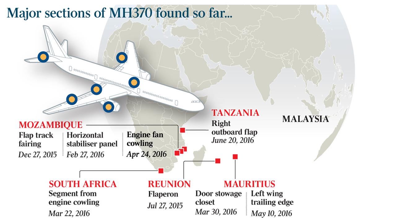 |
| Source: The Australian, 1 August 2018. |
[Comment: The plane had enough fuel on board for a flight lasting approximately 7 hours 31 minutes. With departure at 12.42am and arrival at Beijing expected at 6.30am, the allocated flight time was 5 hours 48 minutes. Based on a disappearance time of 9.34am, the plane actually flew for 8 hours 42 minutes, which is 1 hour and 11 minutes longer than the allocated time. This could have been accounted for by inclusion of the specially reserved emergency fuel allocation which is never used. Cavaiuolo has suggested a period of just over 1 hour in a glide state (usually can last up to 30 minutes) or some other state, such as time dilation due to operation of the orbs. These latter explanations may not be necessary.]
[Comment: Utilising the folding of spacetime, the three remotely operated orbs enable the airplane to travel from a point of disappearance to a site such as Diego Garcia, south of the Maldives, where it is able to reappear and (1) be landed safely on the ground; (2) ditched in shallow water, or (3) subject to a catastrophic fall from the sky into the ocean, resulting in a large debris field. The first two scenarios would enable retrieval of bodies and some personal effects, and a minimal debris field. There are no records of any survivors. One remote viewing session reported a catastrophic ditching of the plane in water close to an island or to rescue boats (Paranormal Viewing 2023). Diego Garcia's large underground facilities may have been then utilised during the operation to hide the plane.]
- According to an article first published on 15 March 2014, there are three Diego Garcia options: (1) The plane ran out of fuel and crashed into the sea close to Diego Garcia; (2) the plane was forced to land on the runway at Diego Garcia, a highly restricted area; (3) the plane headed towards the US base, was given multiple warnings by the American forces, did not respond or change course (remember its communications systems were switched off) and was inevitably shot down as it approached the base.
- A psychic viewing published on YouTube on 19 March 2014 stated the following in regard to the fate of the people on the plane after its ditching / landing: I see them on an island. I see people on an island, on the shore of a small island, and I see guns. I see big guns, like machine guns, or assault weapons, and I see the [people] being pushed along, like "Hurry it up. Hurry along here!" They are pushing them along, nudging them with the guns. I don't feel like everybody is alive either. I feel like some are, but I think not everybody is alive..... I also believe in multiple timelines and stuff, so it could be something like that. But I do keep seeing it..... I feel like it's a very small [island] and secondly I don't feel like you would see the plane from the air. I feel like if there's a plane on there it's covered in vegetation, not because it's been there a long time intentionally, but intentionally covered with green stuff, just so it wouldn't be visible from the air. But I've seen the [people] on the shore. I see guys with guns and I see them pushing the people with the guns, hurling them along. But I don't think there was hundreds of people on that flight. It doesn't feel like hundreds at all, and the number 16 comes to mind. I don't want to say that there's only 16 people....
- According to one 2015 analysis, the plane travelled a further 650 km west of the Maldives after a journey of approximately 7 hrs 19 minutes (Goldie 2015). This does not agree with the official statement by the Prime Minister of Malaysia that the plane crashed in the middle of the Indian Ocean off the coast of Perth, Australia, or with the above presented scenario which indicated a final location at the Maldives or Diego Garcia to the south of the Maldives.
---------------------
3. Summary of available evidence
A range of primary and secondary evidence is available relating to the flight of MH370. Unfortunately this evidence does not lead to any definitive conclusions regarding what happened on board and the plane's ultimate fate. In the absence of finding the wreckage and black boxes, there is the likelihood that the fate of flight MH370 will never be known. All we have to go on at this stage is the following:
* Radar - Primary (ground-based) and secondary (satellite-based) radar is available for sections of the flight. The primary radar is both civilian and military. It seems that the latter has only selectively been released, giving rise to concerns regarding a coverup. Also, no United States radar information has been publically released, though the US military was operating in the region at the time and has comprehensive coverage of the whole planet. This is extremely suspicious and suggests that there is something to hide there.
* Satellites - Data from secondary radar and satellite video is available. As secondary radar connectivity went down due to suspected fires and power losses on the aircraft, it is not consistent. Also, the Inmarsat data was wrongly interpreted at the outset, leading to a continuing search in the southern Indian Ocean off the coast of Australia. A correct interpretation of the data clearly indicates a path west towards the Maldives and Diego Garcia. For some reason this data and interpretation, which has been available since 2016, has been ignored by the authorities. Therefore 99% of the commentary on the fate of MH370 is wrong and has led to accusations of a murder-suicide plot by the pilot, despite a lack of evidence.
* Video - Data from a US spy satellite is available. As with the aforementioned radar data, the United States has not officially been forthcoming with any data on the missing flight. The two videos from a satellite and a drone were released by a whistle-blower who was subsequently jailed. This confirms not only the coverage available to the Americans, but their intervention in the ultimate fate of the plane. It is likely that this data will never be officially confirm and further data revealed.
* Sightings - These occurred in the South China Sea after the initial turn back and whilst the plane was obviously on fire; in the Strait of Malacca near the Nicobar Islands when, once again, evidence of an onboard fire was seen; and over the Maldives. The latter observances by numerous eye witnesses has been ignored by the official investigators as it does not tie in with the initial, and erroneous, Inmarsat data interpretation.
* Debris - This was primarily located south and south-west of Diego Garcia. It includes wing parts and interior parts. The small number of pieces located, and the lack of a discoverable debris field, suggests a low speed ditching in the ocean, rather than a catastrophic landing at speed, on land or sea. The location of the debris finds also points to a nearby landing / crash, around the area of Diego Garcia or, possibly, the Maldives. It does not support the ongoing search off the coast of Australia, where there has been no debris found, either in the ocean or on the Australian coastline.
* Fire -The plane was both seen on fire, and surrounded by a halon gas orange glow, which points to the use of fire extinguishers on board.
* Changes in the route - This indicates that at all stages prior to final disappearance, the plane was under human control, due to the strategic changes in direction. This human control was either onboard (i.e. the pilots) or external, by Boeing and the military.
---------------------
4. Salvatore Pais and the Orbs
In a 19 November 2023 interview between Ashton Forbes and aeronautical engineer Salvatore Pais the following was said in regard to events seen on the two satellite and drone videos. The statement arose out of Pais initial viewing of the two videos referred to above:
Pais: When I saw what those orbs did - the locale of points that they formed - and the moment I actually slowed [the footage] down, I saw one of them go in front of the nose of the aircraft, and this was at very high speeds, almost [mach] three or four. I kept on thinking they are trying to form a locus, almost like a spherical bubble around the aircraft. Then I thought more and more. I said, "Oh my God! They are actually - these three orbs - depositing energy at a particular section of SpaceTime to create this breaking of the Schwingl. And if you do that you create a hole in SpaceTime!" And when I saw that, I didn't anticipate the hole it formed, and then I almost saw a ring that formed around the hole. It was like a refraction of the super fluid nature of [SpaceTime] - I said, "Oh my God, this is the Pais effect!" I then had to cool myself down. They would never believe that. Most likely you will have to go through absolute hell to prove that this is the best experimental proof that the Pais effect is real.
Pais then suggested that the orbs were unmanned, autonomous and guided by artificial intelligence and collision avoidance programs, though there was also obvious human input into the operation. Subsequent conversations between Forbes and Pais took place, and the former was eventually able to describe the operation of the orbs with an amount of scientific detail during a subsequent panel interview session.
-------------------------
5. Elizondo video
In July 2024 an excerpt from a book by UFO whistle blower Luis Elizondo entitled Imminent: Inside the Pentagon's Hunt for UFOs was released which referred to a 23 minute video. It was likely dating from the period immediately prior to the loss of MH370, and had similarities to some of the events described above in regard to the temporary disappearance of the plane. Ashton Forbes immediately highlighted the similarities between the two events on X and his YouTube channel. Th Elizondo video has not been released. The quote from his book verifies much of what Forbes has outlined in his own work:
Another UAP video to hit my inbox involved a Predator unmanned aerial vehicle (UAV) drone conducting surveillance of a nuclear facility in a particularly hostile country when its camera picked up 3 luminous objects. Just 3 dots. Unexplainably the dots began to fly in a regimented formation - a perfect triangle. As the dots approached the Predator they became more distinguishable. They were not only flying, but were solid in structure. For 23 minutes these craft tormented the Predator. They traversed 60 miles in the blink of an eye, traveling to the horizon only to dart back and shadow the Predator within a few hundred feet. If that were not amazing enough, the 3 craft would routinely re-orient themselves, switching from a wedge formation to a linear formation. As they danced across the sky they appeared to be toying with our Predator. "See what we can do and you can't!" was the message I felt in my gut. The craft seemed curious about the Predator after coming in for closer inspection.
Elizondo is notorious amongst the UFO fraternity for dropping hints but never really revealing much. It is believed by many that he is part of the continued non-Disclosure initiative by the Black Hats of the military / political / industrial complex. As such, the present writer would read his account as a video of a test by the US in manipulating the 3 orbs and using the Predator drone to record their actions. Identical orbs and a drone were used in the transfer of MH370 through a wormhole from the Strait of Malacca to closer to the Maldives in the Indian Ocean. This is an obvious use of Alien technology.
-----------------
6. Discussion
In trying to understand and solve the mystery of the disappearance of MH370, a number of options / scenarios have been proposed. The discussion above includes just two of the many presented since the plane first disappeared. They can be summarised as follows:
1. The plane was hijacked by the pilot and/or co-pilot in a murder-suicide scenario. He/they killed all the passengers and crew by flying to an altitude above 40,000 feet early in the flight, and then flying the plane into the Indian Ocean until it ran out of fuel. It was then crashed or ditched. This scenario was reinforced by the testimony of former Australian Prime Minister Tony Abbott and arose during March-April 2014. The FBI suggested that there was crew involvement in reprogramming the autopilot.
Summary: Rejected due to lack of evidence.
2. The plane was hijacked by another person or persons on board, apart from the pilots, and subsequently crashed or ditched. All on board were killed either during the flight or at the end. The plane may have been shot down by the US military in connection with this scenario.
Summary: Rejected due to lack of evidence.
3. A fire on board knocks out electrical systems, damages the plane, and affects all those on board. The pilots try to land the plane but are unable to do so and, as with the passengers and crew, eventually succumb to the effects of the fire. The fire on board was part of a coordinated operation by Motorola and the military to take control of the plane so that it did not reach China, kill all the staff of Superconductors on board, and destroy all the evidence, including a load of superconductor chips. The US military undertook a controlled remote control interception shortly after the fire took over and the plane turned around. The plane was then landed at, or near, Diego Garcia and remains secreted away, part of the ongoing coverup.
Summary: Truth.
These scenarios, and slight variations by the present author of the Forbes and Cavaiuolo scenarios, do not, of course, align with the official line that upon reaching the Nicobar Islands the plane turned south into the Indian Ocean and flew on until it ran out of fuel and crashed off the coast of Western Australia. No evidence for such a crash was ever found, despite an extensive search. The reason for that is that the Forbes scenario provides an explanation for the fate of MH370 which does not align with public belief and only best aligns with information which is considered Above Top Secret by the US authorities and their allies. Such information is protected by US legal constraints that demand those aware of it must lie if requested to reveal any aspects. If they tell the truth, or become whistleblowers, they can be imprisoned, as happened to Lt. Commander Edward C. Lin, the person who released the two MH370 satellite and drone videos in March and June 2014. Likewise, the Cavaiuolo information is ignored as it reveals elements of the truth. The Forbes scenario also aligns with the information gathered by researchers such as Marc Dugain at the Maldive Islands. It would thus appear that the combination of the use of auto-pilot and then remote control of the disabled aircraft resulted in its erratic flight southwest over the Thailand - Malaysian border, then two turns north and north west over the Andaman Sea towards the Nicobar Islands. At that point the back-engineered Alien orbs were introduced into the military-controlled operation and the plane was ultimately warped to an area west of Sumatra and towards the Maldives. It then reappeared and, whilst still under remote control, after circling the Maldives 2-3 times it slowly (circa 250 km/h), and at a low altitude, headed south towards Diego Garcia. Here it was likely landed, or ditched in the ocean nearby. Alternative endings suggested by recent remote viewings include re-ignition of the batteries and an associated explosion which resulted in its crashing into the sea, or being meaningfully shot down by US aircraft with the same fate. The scenario of a low speed landing at Diego Garcia is the most feasible, as it would result in a minimum amount of debris, as is the case, though some debris may have been generated during the period of flight from the Maldives to Diego Garcia, such as the used fire extinguisher sphere. A destructive, explosive crash landing would have resulted in an extensive debris field which it would have been very difficult for the US military to conceal, and which was never actually found or created.
It can be seen from the above analysis, that the only scenario which explains what happened to MH370 is one which involves numerous examples of the most secret technologies available to the United States military forces - remote control of commercial aircraft (as identified by President Bush in a post 9/11 speech), spy satellites with video capture capabilities, drones with thermal imaging capabilities, orbs of Alien origin, and craft with anti-gravity and warp drive capabilities. As such, a truth which includes these elements will for a long period be hidden and classified, and the families of those who died on board MH370 will remain in the dark and traumatised as to the ultimate fate of their loved ones. Whilst there is a case for continuing secrecy in regard to some of the technologies which in the wrong hands could be weaponized, this does not require a complete blanket on what happened to the people on board. Nothing less than a revelatory statement of the truth by the President of the United States will suffice.
---------------------
7. Videos
The following videos pertaining to the MH370 mystery are arranged in most recent to oldest order. There are literally hundreds of such videos on social media platforms such as YouTube, Tik Tok and Twitter X which discuss, debunk, and promote aspects of the mystery, including the official line. Only a few of what the author considers the most significant and/or interesting from YouTube are listed.
* A new trace! The MH370 story so far, Mentour Pilot, 17 March 2024, YouTube, duration: 56.05 minutes.
* MH370X - all evidence review, Ashton Forbes, 8 March 2024, YouTube, duration: 147.59 minutes.
* Inside the Investigation: The Search for MH370 Truth, Channel 7 News, 8 March 2024, YouTube, duration: 32.21 minutes.
* MH370 Documentary, History Calling, 5 March 2024, YouTube, duration: minutes. A good summary of the official narrative concerning the disappearance.
* Cold Case - What happened to Malaysian Airlines Flight MH370?, Ellie Dreams I, 11 February 2024, YouTube, duration: 32.28 minutes. Highlights the coverup / conspiracy aspect.
* The mystery of MH370 - what went wrong?, Spark, 6 January 2024, YouTube, duration: 46.20 minutes. Includes the lithium-ion battery fire scenario.
* Ashton Forbes, Artisan Tony, 5 February 2024, YouTube, duration: 132.26 minutes. Panel discussion.
* Was MH370 sucked into a wormhole?, The Lore Lodge, 20 November 2023,YouTube, duration: 105.40 minutes. Panel discussion.
* Con-Spirit-See: Flight MH370 - Still Missing - Where is it?, Mystical Fortunes Mysteries, 4 November 2023, YouTube, duration: 38.17 minutes. Tarot reading: the plane was shot down and landed in the sea.
* The truth of the missing Malaysian Airlines flight MH370, Wonder, 15 September 2023, YouTube, duration: 45.49 minutes. Briefly discusses the lithium-ion battery scenario.
* Jeff Wise and Andy Tarnoff, Episodes 1-28, Deep Dive MH370, 7 September 2023 - 28 March 2024, YouTube, duration: circa 30 minutes. A series of podcasts and videos.
* What really happened to the missing Malaysian Airlines flight MH370?, The Infographics Show, 18 July 2023, YouTube, duration: 28.07 minutes.
* Flight MH370 Malaysian Air crash [remote viewing], Paranormal Viewing, 28 April 2023, YouTube, duration: 56.04 minutes. Comments: .... a big boom.... lights in the sky.... giant flash .... explosive effects ... everything ends up on the ground ... an invention blows up .... taking down an airplane secretly ..... a plan to intimidate ...an explosive on the plane ... the lock on [of the orbs?] ... a diversion ... wet, water, a boat with a megaphone .... "All aboard" .... people being pulled out of the water .... someone washed up on the shore .... wall of heat, flames behind person .... wafting smoke, people crowded together, crying ... something in the air, rotating, revolving, magnetic propulsion ..... energy came down and expanded outwards .... airdrop and possible survivor ..... waves moving outward in a circular pattern ....stationary object but a field rotating over the surface, electromagnetic...
* What happened to the Malaysia flight MH370? Psychic sector reading, Channeling Erik, 7 April 2023, YouTube, duration: 57.37 minutes.
* A psychic connection to the disappearance of flight MH370, The Fine Art Medium, 15 March 2023, YouTube, duration: 43.45 minutes. Identified the black smoke in the plane from the catastrophic lithium battery fires and the ultimate crash at sea involving the loss of a wing, perhaps due to weakening of the fuselage arising out of the cargo bay explosions and fires.
* The secret story behind flight MH370, Best Documentary, 2022, YouTube, duration: 59.51 minutes. AI generated English version.
* Malaysia Flight 370 - A Tarot Reading, Miss B Tarot, 14 December 2020, YouTube, duration: 20.38 minutes. Very interesting reading in regard to what happened on board during the flight.
* The Disappearance of Flight MH370, Bedtime Stories, 18 February 2019, YouTube, duration: minutes. Discusses the Diego Garcia option.
* Vital data to locate MH370 is mysteriously missing, Discovery Australia, 4 July 2020, YouTube, duration: 7.56 minutes.
* MH370 "island" conspiracy theory doesn't die, CNN, 9 April 2014, YouTube, duration: 2.50 minutes. Refers to Diego Garcia.
* Missing Malaysia Airlines flight MH370 - the story so far, day 17, SKY News, UK, 25 March 2014, YouTube, duration: 47.56 minutes.
* The MH370 Mystery: Where is the missing plane?, 60 Minutes Australia, 23 March 2014, YouTube, duration: 27 minutes.
* The mysterious case of Malaysia Airlines flight MH370, CBC News, 20 March 2024, YouTube, duration: 11.34 minutes.
* Malaysian Airlines flight 370 - psychic impressions, 19 March 2014, YouTube, duration: 3.20 minutes.
* Malaysian Airlines Mystery: Satellites Spot Floating Objects, ABC News, 13 March 2014, YouTube, duration: 2.37 minutes. The 'floating objects' were actually the three flying orbs.
* Malaysian Airlines flight 370: Chinese satellites finds floating objects, On Demand News, 13 March 2014, YouTube, duration: 1.00 minutes.
---------------------
8. Letter to Ashton Forbes
* Diego Garcia whistleblower's letter to Ashton Forbes, Real Creepy stories, YouTube, 10 January 2024, duration: 10.54 minutes. A transcript follows.
[Introduction] This is a submission sent to us the 8th of January 2024. It's a letter to an Ashton Forbes telling a new story of what happened to Malaysian Airlines MH370 that disappeared back in 2014 and, as always, don't trust what you read on the news; trust your own capability to see the world for what it really is. Here we go.
[Letter writer] I work, or have worked, at a military base in the Maldives and I know exactly what happened to Malaysian Airlines MH370. This is also a letter to Ashton Forbes. You are not wrong and what you do is much bigger than you even can imagine. Don't stop what you are doing.
I won't tell anything about myself more than that I currently, or in the past, have spent time at a military base in the Maldives; that I have done this type of work since I joined the military when I was young and that was many decades ago. [I am] still in the game, but the years are starting to get to me. I write this because I want the world to know that most of the troubles on Earth are created for political reasons. The United States, or at least a covert administrative elite of the US, has, at will, complete control, and this has been true since the Sixties.
Flight MH370 arrived at our base by our hand at 18.56UTC after we picked it up mid-air outside the island of Great Nicobar. [This is] just one of many many things we do. We can pick up anything, anywhere, and deliver it in an instant, like a magic FedEx.
Some facts about why it happened: MH370 had defectors on board. They were running to China with American technology. They are Chinese by blood and had gotten themselves into a situation with the Chinese regime, who got them to choose to defect. The whole play, everything, and I mean everything about it, was a political play to show the Chinese who's their daddy. That's us.
Some facts about how it happened: All passengers are dead; all but the handful of defectors. The plane did not crash. The plane was on fire. We know, because we started it. The plane was picked up by us on fire, mid-air, right in front of the Chinese. The Chinese regime knows exactly what happened, and that was the whole point of the operation.
Okay, this is what I want to share with you. As I said, I have been doing this for a long time; I know the technology and have been a part of hundreds of operations. So let's start with the tech.
The foundation is not superconductivity; superconductivity is a product of the technology. We have had this since the 1960s, and from that first day we have used it to make sure that no one else can have it. The big breakthrough - to apply the tech as we do today - came in the beginning of the 2000s with quantum computers, and by this the paradigm for AI technology. What we had to do programmatically before, we now can do with something akin to machine intuition. This lets us operate in fast-moving environments, where event-based logic in linear programming was [in the past] very limited.
As I said, what you have found is not the technology itself; it's just one of many derivatives of the technology. I encourage you to keep on with what you are doing, but you should also be aware that there is a deeper layer that you could focus on instead of the Miami aliens that I see you have been posting about. I will give you some pointers for this at the end of this letter.
The products, or application, you are now working on is correctly based on super conductivity. The number of orbs you've been speculating about is correct - the fourth orb decides where the object ends up. The technology is based on structures, simple and beautiful structures that lets us use the unlimited power that is everywhere, and step outside what I would like to describe as perceived reality. The structure that is used for what you are looking at is a meta structure that creates a low complexity and relative low energy phase transition. The beauty of this technology lies in its elegance and simplicity. The structures are inherently stable and self-regulating and the earlier challenges to conduct operations were 100% based on the limits of man. With the same technology, just a slightly altered mono structure gives us an infinite power generator that, without maintenance, can run forever. Combine structures to a meta product again and you have the propulsion for a trans-medium object moving faster than light. It's the definition of magic.
There are endless applications, and the truth is that it would change the world in an instant. But that won't happen. I bet yourself, or at least most of your audience, have heard a version of the story that the aliens are here and they want to bless us with new clean and revolutionary technology, but we are a too young and rowdy civilization and would not be able to be responsible enough with the gifts from them. That's probably made up, but that is at the same time completely true. It's just not aliens saying this - it's us again. The technology is infinite in its power and if two rivaling parties had access to it this world wouldn't last a day. The same technology with a combination of mono structures makes a terrifying weapon that turns any matter into dust and that dust turns into air. It does not matter if the object is a small bird or a aircraft carrier - it cannot be stopped; it does not miss, and when the object has been hit the phasing cannot be stopped.Okay, so back to MH370.
We knew about the defectors as soon as they made their decision. Well, before that, but then they weren't defectors. Anyway, we knew when, how, and why back in December [2013] and, as we do, we made it into politics. We let them go. We took them back and sent the Chinese a clear message of who is in control, and we did this with a brilliantly produced show that is fit for a Hollywood production.
Any good movie has fire, desperation, regret, and drama, and every movie villain should see their plan fall apart; and in really good movies, just when the villain has accepted that the plan has failed, the heroes of the movie steps in and makes it worse. This is what happened.
As soon as we knew what plane was the last leg of their journey, we planned and delivered. So the plane was loaded up with lithium ion batteries built by us for this occasion. Lithium ion batteries cannot be put out, have a predictable burn rate, and we made sure that the volume was just right for a long burn that would allow for a full length show.
The Chinese were following the plane since it was on the tarmac, and got to see their most close to success operation go up in flames; and just as all hope was lost we made it worse, right in front of their eyes. 2 hours and 13 minutes in they saw the plane get phased out of there by the same technology they were trying to get access to, and 5 days later the Chinese officially made a gesture of submissiveness by publishing a frame from the satellite of the phase moment, via the state Administration for Science. The publishing was talked about in American newspapers as a possible debris field, but when you know what you are looking at, it's clear what the frame shows.
The aftermath. During the days after the show the Chinese found out about the batteries - that we both made and placed them on the plane. They accepted that we have been playing with them the whole time, and at the same time could accept that the people they had convinced to defect did what they wanted. It was us that stopped them. The defectors had a good corrective experience when it comes to staying loyal, and were back on the job as usual, but with a new understanding both of their importance and the consequences of their actions.
What was nothing more than another Friday at the office for the administrative elite, 200 people had the most confusing death experience you could imagine. 1,500 people lived a tragedy, losing family members in a mystery and tens of thousands spent months searching and millions speculating for years.
Then in 2014 military footage of the event got published on YouTube. Not our problem. The person responsible for the leak was identified and taken care of. Not by u. Not our problem. Then came you. Hi Ashton. Impressive.
This is what I want to leave you with. There was a guest on The Joe Rogan podcast that was talking about sacred geometry and some new technology his friends had discovered on some island somewhere. He did record another episode, but it's never been published.
Doesn't the wording sacred geometry remind you of something? If you choose to spend time on this, which I think you should instead of Mall aliens, keep in mind that you're case is one product of the technology. What happens on the other island - you will understand this if you pursue it - is another more rudimentary product. What if those, in combination, could lead you on the right path, to the actual technology? The gray bearded man is the key and he probably has no idea that he is.
Finally, I want to say this: How do you defeat someone who can turn skyscrapers to dust, completely erase whole neighborhoods in an afternoon, and steal a burning Boeing triple seven mid-air; someone who, when needed, has the complete control of all media and crafts the perception of events, and has most of humanity eating from its hands?
After almost a full life in their service, I think I know the answer. You talk about them, and you don't stop talking.
----------------------
9. References
A psychic connection to the disappearance of flight MH370, The Fine Art Medium, 15 March 2023, YouTube, duration: 43.45 minutes.
ABC News, America, Satellites spot three large objects near Malaysia Airlines flight path, ABC News, America, 12 March 2014.
ABC News, Australia, Malaysian Airlines MH370: Military denies missing plane detected on radar far from flight path, ABC News, Australia, 12 March 2014.
-----, Malaysian Airlines MH370: China satellite finds 'floating objects' in hunt for missing plane, search at site fruitless, ABC News, Australia, 13 March 2014.
Atchia, Michael, Flight MH370: The Diego Garcia scenario (revisited), Defimedia.info, 15 March 2014 (11 April 2016).
ATSB, MH370 - Definition of Underwater Search Areas, Australian Transport Safety Bureau, Canberra, 26 June 2014, 64p.
-----, The Operational Search for MH370, Transport Safety Report - External Aviation Investigation, Australian Transport Safety Bureau, 3 October 2017, 440p.
Birchall, Guy, MH370 pilots 'killed instantly after fire started in cargo hold and flames engulfed plane,' The Irish Sun, 24 November 2018.
Belzer Richard, George Noory and David Wayne, Someone is Hiding Something: What Happened to Flight MH370, Nero Books, 2015, 240p.
Biggest Mystery - What really happened to Malaysian Airlines flight MH370?, InfoBard, 15 January 2024, YouTube, duration: 11.21 minutes.
Branigan, Tania and Jonathan Kaiman, Confusion over last known movements of Malaysian Airlines plane, The Guardian, 12 March 2014.
Cavaiuolo, Sergio, The Path to Flight MH370, 8 March 2022, The Author, 125p.
-----, Appendix 1: HRTT Analysis of MH371 satellite data (9M-MRO's previous flight) [7 March 2014], 4 April 2022, The Author, 14p.
Cawthorne Nigel, Flight MH370 - The Mystery, John Blake, London, April 2014, 246p.
CBC News, Malaysia Airlines flight MH370 not tracked to Malacca: air force, CBC News, 11 March 2014.
Chris Not So Deep Podcast, MH370 Flight Path [animated], Ashton Forbes, 1 December 2023, YouTube, duration: 0.54 minutes.
CNA Insider, The Mystery of Flight MH370 (Part 3/4), CNA Insider, Singapore, YouTube, duration: 12.40 minutes.
-----, Flight MH370 Vanished 10 Years Ago: What's Happened Since?, CNA Insider, Singapore, 8 March 2024, YouTube, duration: 47.23 minutes.
Corpuz, Rachel, MH370: U.S. refutes claims plane lands in Diego Garcia, International Business Times, 12 April 2014.
Coulthart, Ross, MH370: Special Investigation, Part 1 | Part 2, 60 Minutes Australia, 31 July 2016, YouTube, duration: 23.46 minutes.
De Changy, Florence, The Disappearing Act: The Impossible Case of MH370, HarperCollins, 2022, 448p.
Ducey, Liam, Curtin University researchers find possible acoustic trace of MH370, WA Today, 4 June 2014.
Dugain, Marc, French ex-airline boss claims coverup on MH370, France 24, 18 December 2014.
Engel, Pam, Exploding batteries in MH370 cargo hold, Business Insider, 16 October 2015.
Flight MH370 Malaysian Air crash [remote viewing], Paranormal Viewing, 28 April 2023, YouTube, duration: 56.04 minutes.
Forbes, Ashton, Was MH370 sucked into a wormhole?, The Lore Lodge, 20 November 2023,YouTube, duration: 105.40 minutes.
-----, MH3370 Stereoscopic satellite video, 8 March 2014, Ashton Forbes, YouTube, 23 November 2023, duration: 2.03 minutes.
-----, MH370 MQ-1C, thermal video 8 March 2014, Ashton Forbes, YouTube, 26 November 2023, duration: 2.16 minutes.
-----, Ashton Forbes, Artisan Tony, 5 February 2024, YouTube, duration: 132.26 minutes.
Goldie, Stephen, Is MH370 650km west of the Maldives?, LinkedIn, 6 August 2015.
Goodfellow, Jeff, A startlingly simple theory about the missing Malaysian Airlines jet, Wired, 18 March 2014.
Iannello, Victor, Some Observations on radar data for MH370, Duncan Steel [blog], 18 August 2015.
-----, Questions about the radar data for MH370, Duncan Steel [blog], 24 September 2015.
-----, Radar maybe captured fighter jet intercepting MH370, Radiant Physics [blog], 2 March 2017.
Irving, Clive, Flight MH370 was carrying 440 pounds of dangerous batteries, The Daily Beast, 1 May 2014.
-----, The deadly cargo inside MH370: How exploding batteries could explain the mystery, The Daily Beast, 15 October 2015.
Kadri, Usama, Rewinding the waves: tracking underwater signals to their source, Scientific Reports, 27 October 2017.
-----, New underwater sound wave analysis suggests alternative travel route and new impact locations, The Conversation, 29 January 2019.
Koswanage, Ninuskli and Eveline Danubrata, Malaysian Airlines flight 370: Why the search has drifted dramatically, The Christian Science Monitor, 11 March 2014.
Lagrone, Sam, Edward Lin will serve 6 years for mishandling classified information and not reporting foreign contacts, US Naval Institute News, 2 June 2017.
Lo, Tiffany, Flying orbs filmed spinning around the plane 'shows proof of teleportation' and MH370 theory, The Star, 13 August 2023.
Lomas, Chris, 10 Years On - How MH370 changed flight tracking and aviation safety, flightradar24, 2024.
Lusher, Adam, As MH370 conspiracy theories continue to swirl, why has compelling new evidence not revived the search?, The Independent, 25 April 2017.
Martinez, Michael, Flying low? Burning Object? Ground witnesses claim they saw flight 370, CNN, 20 March 2014.
MH370 - Plane truth still unclear, The Australian, 1 August 2018.
My missing Malaysia Airlines flight theory, My Life's A Travel Movie [blog], October 2023.
O'Neill, Marnie, Malaysia, military agencies deliberately withholding radar data that could help find MH370, news.com.au, 20 January 2017.
Pattiaratchi, Charitha, MH370 disappearance 10 years on: can we still find it?, The Conversation, 5 March 2024.
Richard, Pilot says batteries downed MH370, UPS Battery Centre, 12 November 2018.
Rivers, David, MH370 pilots 'killed instantly': Crew wiped out as 'flames engulfed Boeing 777,' Daily Star Online, 24 November 2018.
Rosemurgey, Emma, New claims challenge the loss of flight MH370 ten years on, Unilad, 3 March 2024.
Safety Investigation Report - Malaysian Airlines Boeing B777-200ER (9M-MRO) 08 March 2014, The Malaysian ICAO Annex 13 Safety Investigation Team for MH370, 2 July 2018, 495p.
Sanchez, Raf, MH370 hijacking theories, CNN.com, 14 March 2014.
------, Missing Malaysia Airlines flight MH370 - were crew trying to save smoke-filled plane?, The Daily Telegraph, London / Sydney Morning Herald, Sydney, 20 March 2014.
Scruton, Paul, Claire Phillips and Cath Levett, Missing MH370 - A visual guide to the parts and debris found so far, The Guardian, 17 January 2017.
Shears, Richard and James Rush, Nine fresh witnesses place missing plane near Thailand, Daily Mail, 12 March 2014.
Taylor Joshua, Missing Flight MH370 final report reveals crucial new evidence about huge battery cargo in hold for first time, The Mirror, UK, 30 July 2018.
The secret story behind flight MH370, Best Documentary, 2022, YouTube, duration: 59.51 minutes.
Unraveling the Enigma: Lt. Cmdr. Edward Lin, Naval Black Programs, and the Mysterious MH370 Footage Leak Investigation, Reddit, December 2023.
Vance, Larry, MH370: Mystery Solved, Group of Three Publishing, 2018, 146p.
What happened to the Malaysia flight MH370? Psychic sector reading, Channeling Erik, 7 April 2023, YouTube, duration: 57.37 minutes.
Wilson, Evan and Geoff Taylor, Goodnight Malaysian 370: The Truth Behind the Loss of Flight 370, Wilson Aviation, 2014, 256p.
Wise, Jeff, The Taking of MH370, The Author, 2019, 191p.
-----, MH370 Disappearance: A "Startlingly Simple Theory" about the missing airliner is seeping the internet but it's wrong, Slate, 18 March 2014.
----- and Andy Tarnoff, Episodes 1-28, Deep Dive MH370 [YouTube Series], 7 September 2023 - 28 March 2024.
---------------------
The extremely tragic nature of the loss of 239 [220] lives on board MH370 is herein recognised. May they rest in peace.
---------------------
MH370 : A fictional scenario | Edward C. Lin | MH370 | Russia & China | Sergio Cavaiuolo analysis | TR-3B | Video presentation |
ETs & UFOs : | 1971 Australian File | Elena Danaan | Events, film and books | F.W. Birmingham, Parramatta Park, Australia 1868 | Flying Saucers over Australia 1950 | Martin Sharp, LSD & UFOs 1960s | Maria Orsic | Mayan Alien & UFO hieroglyphs | MH370 2014 | Mount Zeil, Australia | Mussolini's UFO 1933 | Origins | Shirley UFO 1952 | TR-3B | UFOs, Aliens and the Vatican + References | Wilson/Davis transcript 2002 | Zero Point Energy |
Last updated: 15 September 2024
Michael Organ, Australia (Home)


Comments
Post a Comment